AMID FEARS OVER the possibility of “The Big One” hitting Metro Manila and adjoining provinces, seismic experts have started looking into the probability that the earthquakes which struck in succession in the last 14 days may have triggered both active and dormant faultlines.
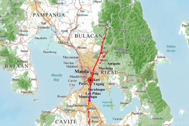
For one, Metro Manila sits directly atop the West Valley Fault, which in itself may trigger a magnitude 7.2 quake.
According to Philippine Volcanology and Seismology Director Teresito Bacolcol, not even a half kilometer distance from the can guarantee safety.
“Even if a house is 500 meters away, if it’s not well-built, it could collapse in intensity 8 shaking,” he said. Some cities have marked fault traces: “Pasig and Quezon City have put up markers so people know where the fault runs.”
However, the recent earthquakes triggered by the so-called Philippine Trench, could have rattled fault lines that had lain dormant for centuries – including the West Valley Fault which traverses adjacent provinces.
3,224 QUAKES IN 14 DAYS
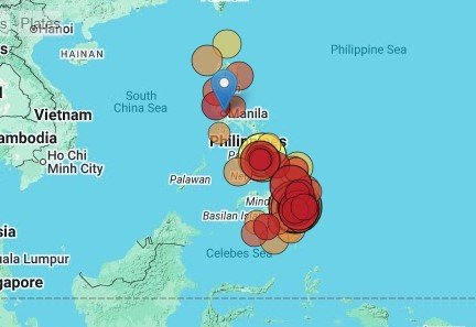
According to data collated from volcano discovery.com, the Philippines has had 3,224 quakes of magnitudes up to 7.4: in the last 14 days.
- 1 quake above magnitude 7
- 3 quakes between magnitude 6 and 7
- 26 quakes between magnitude 5 and 6
- 133 quakes between magnitude 4 and 5
- 459 quakes between magnitude 3 and 4
- 1,573 quakes between magnitude 2 and 3
- 1,029 quakes below magnitude 2 that people normally don’t feel.
On the average, the number of earthquakes based on data from the past 25 years and local earthquake archive back to 1900, there are about 13,000 incidents of temblor hitting the Philippines per year.
- Mag. 8 or higher: 0.03 quakes per year (or 1 quake every 31.3 years)
- Mag. 7 or higher: 0.93 quakes per year (or 1 quake every 1.1 years)
- Mag. 6 or higher: 6 quakes per year
- Mag. 5 or higher: 72 quakes per year (or 6 quakes per month)
- Mag. 4 or higher: 754 quakes per year (or 63 quakes per month)
- Mag. 3 or higher: 2,900 quakes per year (or 7.9 quakes per day)
- Mag. 2 or higher: 10,000 quakes per year (or 28.6 quakes per day)
- Mag. 1 or higher: 13,000 quakes per year (or 36.8 quakes per day)
HIGH SEISMIC LEVEL
Situated in the so-called Ring of Fire, the Philippines has a very high level of seismic activity – proof of which is the occurrence of at least four tremors above magnitude 8 since 1900, suggesting larger earthquakes of this size occur infrequently, probably on average approximately every 30 to 35 years.
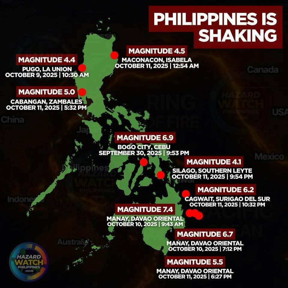
Magnitudes 6.9 and 6.0 earthquakes that struck Cebu on Sept. 30 and October 13, magnitudes 7.4 and 6.8 which shuddered Davao Oriental on October 10 and other midrange temblors in shaking provinces in Luzon and in the Visayas region raised concerns over the Philippine Trench encompassing the archipelago.
Most recent seismic activities served as a stark reminder of the urgent need for preparedness against the next major earthquake threatening lives of an estimated 14 million people in Metro Manila.
Several local government units in Metro Manila and adjoining provinces have already started distributing survival kits.
EARTHQUAKE STATS
According to Phivolcs, the agency has been recording an average of 30 quakes per day coming from different active faults and trenches.
In an interview on Bilyonaryo News Channel, Bacolcol detailed the risks and the measures both government and communities are taking to protect lives and infrastructure.
As of early Oct. 1, Bacolcol reported 9,887 aftershocks following the magnitude 6.9 earthquake that struck Bogo City and Cebu. “In the first 24 hours, we recorded about 2,000 aftershocks. By the 10th day, that number dropped to 200-300. After 100 days, only 20-30 remain, and these are barely felt – only our instruments detect them,” he said.
The twin earthquake in Davao however yielded higher numbers. According to Phivolcs data, at least 1,111 aftershocks were recorded as of noon of October 12.
Davao Oriental logged in with eight casualties, sustained damages and displacement of a little less than half million residents while Cebu had over 70 persons dead, massive infrastructural damages, economic slump, chaos, hunger and uncertainty.
HAZARD, RELOCATION
There’s no way to predict or prevent an earthquake from happening but the government has put in place hazard mapping and relocation planning.
“We provide hazard maps and data on active faults so LGUs can plan accordingly,” Bacolcol said.
“We can’t warn when an earthquake will happen,” Bacolcol said. “But we can locate epicenters accurately, especially offshore quakes that could trigger tsunamis.”
Public tools like Hazard Hunter PH and GeoRisk PH allow residents to check earthquake, volcano, and hydrometeor risks, helping plan safe schools and energy facilities.
Government retrofits can help, but engineers stress that following building codes remains the most reliable safeguard. “Participating in earthquake drills helps, but if the building collapses, drills alone won’t save lives. Follow the building code. No cutting corners,” he quipped.